Stealthing the White MountainsAMC Backcountry Camping Rules:
* No camping or fires within .25 (1/4) mile …
…from any hut, shelter, tent platform, cabin, picnic area or campground except at designated sites
…any trailhead
…above tree line (except on 2’ of snow)
…within 200’ of trail
This is now a compilation of a few hikers’ approach to Stealthing/Bootlegging the Whites.After Mt. Moosilauke, before descending Beaver Brook - I've camped nearby the junction of the AT with the trail to Mt. Jim. It's a flat area, sheltered with trees to the L at the junction. I think the trail to Jim is called the Ridge Trail leading to Mts. Jim and Waternomee. It's a dry camp.Bottom of Beaver Brook - lot's of stealth sites before getting to Kinsman Notch/NH Rt. 112, with lots of water nearby. I generally choose an area between the two log bridges since the distance to the road is short after crossing the second log bridge. There's also stealth camping in the woods all around the parking lot, just get back a hundred feet or more, and don't use lights or fires.Gordon Pond – 3.5 miles north of Kinsman Notch (.3m off trail) there is a fork in the trail. Either fork leads to sites, water from pond/stream. Before Mt. Wolf - a side trail leads a short distance (1/2 mile) to Gordon Pond, one of my favorite places. Look for a freshwater spring on the NW side of the pond, a couple hundred feet from some established campsites. This is great moose habitat. In 1936 the AT used this section of trail and then led past the pond to rejoin the present-day AT just before Eliza Brook shelter. The side trail is called Gordon Pond Trail.Eliza Brook Shelter – This is the last free site in the Whites. There are flat camping spots that are past the shelter once you cross the brook. You're within shouting distance of the shelter so this is more like shelter overflow campsites.Fishin' Jimmy Trail - This is on the AT about a mile before the Lonesome Lake Hut. The trail rises to about 3000 feet along the side of The Cannonballs. There are flat areas in the woods (out of sight) to the right. Dry camping. From there is a steady descent to the Hut.Basin-Cascades Trail Junction - If you descend a short distance on the side trail there are flat spots. This is a pretty & dramatic area near the waterfalls. About 1.5 miles past the Lonesome Lake Hut.Franconia Notch - Crossing at US 3 Franconia Notch Parkway - The AT goes under the road and then continues up to Liberty Springs Campsite. Liberty Springs Trail Head Parking is .5m to the right. In 1936 there was an established campsite for hikers about 100 yards from the crossing of Whitehouse Brook. You can still use the flat area, but today you have to move a bit further into the woods. Follow a small stream, south side of stream only 50-100’ off trail flowing from the North that joins the Pemi at this location.Alternative to Liberty Springs – Pick up water at Liberty Springs, head up to jct. with Franconia Ridge Trail and Liberty Springs Trail. Go towards Mt. Liberty (head south) you will be outside the FPA. Go towards the west side of the trail and there are some hardened spots.Garfield Pond - Camp to the R of the AT. (Various sites.) In 1936 this was the shelter location for AT hikers. The current shelter is over Garfield at Garfield Ridge Campsite, another 2 miles N on the AT.Mt. Garfield Summit - Climbing up the old fire tower platform, look down to the right. There is a small 1 person site squeezed between rock/cliff and trees. Carry water from Garfield Pond. - The remnants of the summit building have been used for years by hikers. The ridge runners have been told to ask you to move if they find you there.As an Alternative to Galehead Hut – Pick up water at Galehead Hut. Head up the Frost Trail to Mt. Galehead. At the summit you will see herd paths that lead to some hardened sites.Between South Twin and Mount Guyot – Get water at Galehead Hut – various sites. Closer to Guyot than S. Twin.Zealand Summit - After Guyot, and before the descent to Zealand Hut, there is a short side trail for peak baggers to reach the summit of Zealand. Look for a sign on the L. There's room for a couple of tents, dry camping.Zeacliff Pond - a short descent (steep!) to the Pond from the AT. This was the hiker shelter location in 1936. The pond is not within the Pemi Wilderness so camping is OK. This is about a mile before the trail junction for Zeacliff Trail, about 2-3 miles before Zealand Hut.Past Zealand Falls Hut – after .25m warning sign, walk 150-200 yards, gravel drainage area on right. Walk down 100-200 yards – various trails leading to dozens of stealth sites and 2 streams – invisible to others.Before Rt. 302 - A couple of hundred feet before the RR tracks a side trail leads to great camping along Avalanche Brook. The side trail is called Ripley or Ripley Falls or something like that.US Rt. 302 - .25m in, cross bridge and notice gravel tent area (obvious) on your right – follow stream .25 mile downstream, across from boulder field.Mt. Webster/Top of Webster Cliff – obvious sites available (2-5?) but carry water from streams as you climb up – probably first .5m of ascent. Great views from the top of the cliffs looking into Crawford Notch. Dry camping and lots of wind.As an Alternative to Mizpah Hut or Nauman Tent site – Head down Mt. Clinton Trail… outside the FPA you should be able to find some possibilities.Information – It is a very tough stretch between Mt. Clinton and Mt. Madison. The only suggestion I can give you there is that it would be easier to travel with a hammock there. It would provide you with more camping options and you would lose less elevation gain when trying to find a spot, because you cannot camp above tree line. You will have to dip down to camp. The terrain makes it hard to find a spot that is legal. If you are traveling with a tent you will be able to find some spots, but will lose some serious elevation gain in order to get a decent spot.The biggest “problem area” for finding a site that will not incur you lots of elevation loss is between Mt. Pierce/Clinton and Mt. Madison. It is primarily above tree line and UNLESS you stay at Lakes of the Clouds hut, (sort of halfway), you have a kind of big push with lots of hiking above tree line, (which is NICE in GOOD weather) and some fairly decent elevation gain. The problem with above tree line hiking is that you CAN run into weather that is horrible and you are fully exposed to the wind and weather, and MUST descend to find a LEGAL and SAFE place to camp. There are options if you choose not to stay at the huts, but you will lose elevation gain.Alternative to Lakes of the Clouds Hut – You could head down the Dry River Trail (south of Mt. Washington) and find a spot. You will lose some elevation gain, but it might be your only option if you hit some bad weather.Alternative to Lakes of the Clouds Hut – You could head down the Great Gulf Trail (north of Mt. Washington) and find a spot. Again, you will lose some elevation gain, but it gives you a bad weather option.Alternative to Lakes of the Clouds Hut – Another option is to push to get to either the Perch (tent platforms, great water, and a shelter)… located down off Gulfside, NW of Mt. Jefferson. Other options in this area are Gray Knob and Crag Camp (both Randolph Mountain Club enclosed facilities run on a caretaker basis). Again, you will lose some serious elevation gain there. At the time of this writing (Tent platforms at the Perch are $5, and the Gray Knob and Crag Camp are both $10.} All three of these sites are shown on the NH-VT AT Maps.Edmands Col - between Jefferson and Adams. This historically was an emergency shelter area, lots of flat spots, windy, dry camping above tree line. Not recommended but I've camped here.Madison Hut area - Just to the East is a small lake on side trail descending into Madison Gulf. Flat areas are just past the lake, protected from winds but still above tree line and not recommended. The hut crew will instruct you to descend to the Valley Way tent site about 1 mile down to the North of the hut.[At time of writing, Valley Way tent site is free @ Madison Hut, as is Osgood tent site at Bottom of Madison Mountain. Lakes of the Clouds is kind in bad weather, but the Presidential Range is catch as catch can for stealth sites.]Pinkham Notch – Follow creek downstream, when trail merges away look hard not heavily used. Water from creek.As an Alternative to Carter Notch Hut – Head down the Wildcat River Trail. Just past the FPA are some possibilities. Water is available nearby.Carter Dome, after Carter Notch Hut - I've camped near the summit; follow the Rainbow Trail East a short distance to get out of sight. Dry camp. .25m past Carter Hut – on right – a “cave” of boulders creates 2-4 sites – open top, not really a cave. Water from Carter Hut.Zeta Pass - .25m -.5m past Zeta Pass junction, cross stream, on right.Near Imp Campsite – .5m before camp, when water pools appear, look left.Moriah Summit - historically there was a log shelter at the summit. Flat rock ledges can accommodate some tents. Just to the W along the Carter-Moriah Trail.
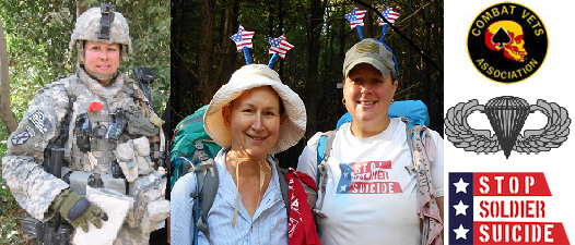
Post War Hike - Combat Vet and Mom on the Trail of Life
Whites Stealth Sites
Subscribe to:
Posts (Atom)
Great. My family have trip next month. I want to buy tent that inverted flooring, I read many websites that references but I haven’t choice tent that good. You have a lot of expriences. Can you give me opinions?
ReplyDelete