We are finishing the Whites and should be in Warren/Plymouth, NH on Monday or Tuesday. At that time we need a ride up to Caratunk, Maine to complete a section of southern Maine we skipped to do the Whites.
Is there anyone who could help us out with a ride from Warren/Plymouth, New Hampshire to Caratunk, Maine?
If so, leave me a voice mail, 404-234-6513.
Thanks, Hendo and Hendo's Mom

Post War Hike - Combat Vet and Mom on the Trail of Life
Friday, October 31, 2014
Wednesday, October 29, 2014
The Gear We Use
Here is the gear we are using. The brands/styles I am listing are what we have or are an ideal recommendation. If you google the items you will probably find them online at different sites much cheaper than on the brand sites I listed.
>Backpack
>Sleeping Bag – you will want a 0-20 degree bag, a Dri-Down(water resistant down) bag is ideal
>Water Purification
>1 carabineer, used to hang food bags at night, hang backpack, retrieve bag or person in case of emergency, etc.
>50 feet 550-cord, used to hang food bags at night, retrieve bag or person in case of emergency
>Small Trowel, your toilet
>Spoon
>Cell Phone, in Ziploc or waterproof case
>Cell Phone Charger
>Camera, in Ziploc or waterproof case
>7L Waterproof bag to store the below miscellaneous items:
++Stove Fuel- if using your jet boil bring 2 small 3.5 oz canisters or one large 8 oz canister.
++First Aid Items: 1 roll athletic tape, 1 tube neosporin, ziploc bag of motrin, tweezers, toenail clippers, 2-2in gauze pads, hydrocortisone cream, small bottle Gold Bond Powder
++Extra set head lamp batteries
++Extra set of batteries for Steri Pen water purification
++Extra set of batteries for camera
++Matches
++Lighter
++Fire starters
++Toothbrush
++Comb
++Chapstick
++any needed medications
>13L Waterproof Clothing Bag – this one bag is what we keep all of the below listed clothing items in:
++Winter gloves/mittens – we have mittens with fold down finger cover, keeps the hands warmer
++Extra pair of pants
++Extra shirt – long sleeve or short sleeve wicking/synthetic material, during the warmer months we carried an extra t-shirt in the cold months we carried an extra long-sleeve shirt
++Extra pair of wool socks
++Sleep bottoms - base layer long underwear, I wear the army issue waffle bottoms
++Sleep Socks - a pair of wool socks
>Clothing to wear
++Long Sleeve or Short Sleeve Shirt – synthetic/wicking material shirt, in the warmer months we wore t-shirts in the colder months we wore long sleeve shirts
++Pants
++Belt
++Wool Socks
++Shoes- trail runners are what we and most everyone out here wears, not boots
++Pocket Knife
++Wallet in Ziploc Bag
++Baseball Cap
>Backpack
- GoLite Jam 50 (Hendo) - http://www.golite.com/Jam-50L-Pack-Unisex-P46812.aspx
- Hyperlite Mountain Gear 3400 Windrider (Mom)- http://www.hyperlitemountaingear.com/ultralight-packs/3400-windrider.html
- ULA Circuit (Common on Trail) - http://www.ula-equipment.com/product_p/circuit.htm
>Sleeping Bag – you will want a 0-20 degree bag, a Dri-Down(water resistant down) bag is ideal
- The North Face (Hendo & Mom) - http://www.thenorthface.com/catalog/sc-gear/equipment-sleeping-bags-filter-category-5-0176-f-25-0176-f/blue-kazoo.html?variationId=L0C&variationName=HONOR BLUE / ASPHALT GREY
- Kelty ( - http://www.kelty.com/p-646-ignite-dridown-0-en-7.aspx
- Thermolite (Hendo & Mom) - http://www.rei.com/item/797114/sea-to-summit-thermolite-reactor-extreme-mummy-bag-liner
- Sea to Summit, size M (Hendo & Mom) – http://www.seatosummit.com/products/display/1
- Closed-cell pad – http://www.rei.com/item/829826/therm-a-rest-z-lite-sol-sleeping-pad
- Big Agnes Insulated inflatable pad (Common on Trail) - http://www.rei.com/item/846692/big-agnes-air-core-insulated-sleeping-pad
- REI Stratus (Mom) - http://www.rei.com/item/870758/rei-stratus-insulated-air-sleeping-pad
- REI Flash (Hendo) - http://www.rei.com/product/845300/rei-flash-insulated-air-sleeping-pad
- Big Agnes Fly Creek UL2 (Common on Trail) - https://www.bigagnes.com/Products/Detail/Tent/FlyCreekUL2
- REI Quarter Dome 2 Tent (Common on Trail) - http://www.rei.com/item/862423/rei-quarter-dome-2-tent
- REI Quater Dome T3 Tent (Hendo & Mom) - http://www.rei.com/product/864812/rei-quarter-dome-t3-tent-special-buy
- JetBoil Sol (Hendo & Mom) - http://www.jetboil.com/Products/Sol-Advanced-Cooking-System/
- Crocs (Mom) – http://www.crocs.com/crocs-classic/10001,default,pd.html?cid=4O5&cgid=men-footwear-clogs
- Sandals (Hendo) - http://www.rei.com/item/865476/teva-original-universal-sandals-mens
- 2 - 1 Liter Nalgene bottles with Humangear Caps (this is what Hendo carries) - http://store.nalgene.com/Water-Bottle-32-ounce-wide-mouth-p/32%20ounce%20wide%20mouth.htm
- Human Gear Caps - http://www.humangear.com/capcap/
- 1 - 1 Liter Nalgene bottle and 1 camelbak (this is what Mom carries) - http://shop.camelbak.com/antidote-reservoir-70-oz20l/d/1096_cl_750
- Sea to Summit (Hendo & Mom) - http://www.seatosummit.com/products/display/64
- FroggToggs (Hendo & Mom)- http://www.froggtoggs.com/mens/all-weather-suits/ultra-lite/the-frogg-toggsr-ultra-lite2tm.html
- FroggToggs- http://www.froggtoggs.com/mens/all-weather-suits/ultra-lite/the-frogg-toggsr-ultra-lite2tm.html
- Sea to Summit (Hendo & Mom) - http://www.seatosummit.com/products/display/4
>Water Purification
- SteriPen (Hendo & Mom) - http://www.steripen.com/adventurer-opti/
- Sawyer Filter (most popular on trail, great option) - http://www.rei.com/item/858764/sawyer- squeeze-water-filter-32-fl-oz
>1 carabineer, used to hang food bags at night, hang backpack, retrieve bag or person in case of emergency, etc.
>50 feet 550-cord, used to hang food bags at night, retrieve bag or person in case of emergency
>Small Trowel, your toilet
- (what we have) - http://www.rei.com/item/407009/u-dig-it-stainless-steel-hand-shovel
>Spoon
>Cell Phone, in Ziploc or waterproof case
>Cell Phone Charger
>Camera, in Ziploc or waterproof case
>7L Waterproof bag to store the below miscellaneous items:
- Granite Gear 7L bag (Hendo & Mom) - http://www.granitegear.com/outdoor/packing-systems/waterproof-
- Peregrine (another good brand) - http://www.peregrineequipment.com/shop-sacks-bags-towels/event-dry-
- Sea to Summit (another good brand) - http://www.seatosummit.com/products/display/64
++Stove Fuel- if using your jet boil bring 2 small 3.5 oz canisters or one large 8 oz canister.
++First Aid Items: 1 roll athletic tape, 1 tube neosporin, ziploc bag of motrin, tweezers, toenail clippers, 2-2in gauze pads, hydrocortisone cream, small bottle Gold Bond Powder
++Extra set head lamp batteries
++Extra set of batteries for Steri Pen water purification
++Extra set of batteries for camera
++Matches
++Lighter
++Fire starters
++Toothbrush
++Comb
++Chapstick
++any needed medications
>13L Waterproof Clothing Bag – this one bag is what we keep all of the below listed clothing items in:
- Granite Gear bag (Hendo & Mom) - http://www.granitegear.com/outdoor/packing-systems/waterproof-
- Peregrine (another good brand) - http://www.peregrineequipment.com/shop-sacks-bags-towels/event-dry-
- Sea to Summit (another good brand) - http://www.seatosummit.com/products/display/64
- Patagonia Down Sweater (Hendo & Mom) - http://www.rei.com/item/871413/patagonia-down-
- Mountain Hardwear Ghost Whisper (common on trail) - http://www.mountainhardwear.com/mens-ghost-whisperer-down-jacket-OM5678.html?dwvar_OM5678_variationColor=345
++Winter gloves/mittens – we have mittens with fold down finger cover, keeps the hands warmer
++Extra pair of pants
++Extra shirt – long sleeve or short sleeve wicking/synthetic material, during the warmer months we carried an extra t-shirt in the cold months we carried an extra long-sleeve shirt
++Extra pair of wool socks
- Darn Tough (Hendo & Mom) - http://www.socksaddict.com/3408-Darn-Tough-Mens-Merino-Wool-Hike-Trek-Boot-Socks---Full-Cushion.aspx
++Sleep bottoms - base layer long underwear, I wear the army issue waffle bottoms
++Sleep Socks - a pair of wool socks
>Clothing to wear
++Long Sleeve or Short Sleeve Shirt – synthetic/wicking material shirt, in the warmer months we wore t-shirts in the colder months we wore long sleeve shirts
++Pants
++Belt
++Wool Socks
++Shoes- trail runners are what we and most everyone out here wears, not boots
- Brooks Cascadia (Hendo) - http://www.brooksrunning.com/en_us/brooks-cascadia-9-mens-trail-running-shoes/110160.html
- Vasque (Mom) - http://www.vasque.com/USD/product/mens-footwear/hiking/mantra-2.0-gtx-beluga-gold-07068
++Pocket Knife
++Wallet in Ziploc Bag
++Baseball Cap
Gotta Finish
I know this is taking us longer than it takes most and recently more and more friends/people I know are telling me I should just quit and come back next year and finish. But unless you have attempted or successfully thru-hiked the Appalachian Trail then you won't understand that I can't, I need to finish because I want to be a thru-hiker.
Our trail friend Drag n' Fly is a great example of the determination thru-hikers have. On two previous occasions Drag n' Fly previously began hiking the trail at Springer Mtn, GA but did not complete the entire trail in one hike, so she was not a thru-hiker. This year, at age 74 Drag n' fly started at Springer Mtn, Ga for a 3rd time and headed north. Yes, she could have just gone back to where she had quit the trail before and finished, but she would have sectioned hiked the AT, not thru-hiked the AT, and Drag n' Fly wanted to be a Thru-Hiker. So she set out for a third time and she did it, she is now an AT Thru-Hiker. And if she can do so can I.
So...I am going to keep on trekking and finish this thing. Mom says she is going to continue on with me as well, but I have made it clear to her she can quit at anytime, but she says she wants to continue on.
Please know that we are being safe and not putting our lives at risk, that is why we have been sitting out the last week here in the Whites, waiting for the weather to clear up so we can finish this crazy weather section. The rest of the trail does not have the extreme winds and weather that the above treeline Whites have.
So if you don't have words of encouragement please don't comment, I just can't deal with the "You need to quit" comments anymore. Too many people have invested too much, time, money and effort for me to quit just because it is taking me a little longer than others. Thank you so much to everyone who has supported us along the way and I will make certain to finish!!!!
Tuesday, October 28, 2014
14-28 October: Trying to finish these here Whites!!!!!!!!!!!!!!!!!!!!!!!!!!!!
So we have the hardest part of The Whites done, The Presidential Range, so let's get the rest knocked out real quick like. Well, Mother Nature again, seems to have a different plan. Neither Mom or myself want to become a rescue statistic, so while we are not sitting out every rainy day, we are definitely listening to the weather forecasts and not putting ourselves in danger.
Tuesday 14 October, we enjoyed a great dinner at an Indian Restaurant in Conway, NH and a nights sleep and shower in a hotel room last night. This morning we had a great breakfast at Peach's and Hendo bought some new Brooks Cascadia shoes. So we are ready to get at it. After a long semi-steep uphill hike out of Crawford Notch, the trail flattened out into a gorgeous and enjoyable stretch of trail to a stealth campsite just north of Zealand Hut.
Wednesday 15 October, Today we left our stealth campsite and headed on south, stopping by Zealand Hut to use the privy. While at the Hut we were offered some breakfast leftovers and gladly accepted and enjoyed!! Then it was onward to Galehead Hut, to ask for Work For Stay and spend another night out of the elements. As the day went on the weather moved in and we ended up getting rained on at the end of the day. The final 0.8 of a mile down to Galehead Hut was quite a doozy, but we made it!! We summitted Mt Guyot and South Twin Mountain today, but were only able to get summit photos with our memorial stones on Mt. Guyot as it was raining when we summitted South Twin and our camera isn't water proof.


The AT is routed up a stream for part of the way leading up to Garfield Ridge Campground and then suddenly the trail Y's off to the left and parallels the stream. So no, you aren't looking at a picture of a stream, that is a picture of the AT. It is really nuts, no reason it couldn't be routed parallel to the stream the whole way.


Tuesday 14 October, we enjoyed a great dinner at an Indian Restaurant in Conway, NH and a nights sleep and shower in a hotel room last night. This morning we had a great breakfast at Peach's and Hendo bought some new Brooks Cascadia shoes. So we are ready to get at it. After a long semi-steep uphill hike out of Crawford Notch, the trail flattened out into a gorgeous and enjoyable stretch of trail to a stealth campsite just north of Zealand Hut.
Wednesday 15 October, Today we left our stealth campsite and headed on south, stopping by Zealand Hut to use the privy. While at the Hut we were offered some breakfast leftovers and gladly accepted and enjoyed!! Then it was onward to Galehead Hut, to ask for Work For Stay and spend another night out of the elements. As the day went on the weather moved in and we ended up getting rained on at the end of the day. The final 0.8 of a mile down to Galehead Hut was quite a doozy, but we made it!! We summitted Mt Guyot and South Twin Mountain today, but were only able to get summit photos with our memorial stones on Mt. Guyot as it was raining when we summitted South Twin and our camera isn't water proof.
Hendo's Mom with MSgt Love's Memorial Stone on the summit of Mt. Guyot
Hendo with SPC Cassavant's memorial stone on the summit of Mt. Guyot
Thursday 16 October, Mother Nature thunder stormed all day today so we spent the day at Galehead Hut, helping clean the privys from ceiling to floor for our work for stay. While looking through the old Hut Logs we found where Earl Shaffer, the first AT Northbound Thru-hiker in 1948, signed the log during his 1965 Southbound Thru-Hike
Earl Shaffer, last entry on page
Friday 17 October, today the storms subsided so we ventured on southward and ended up at Garfield Ridge Campsite for the night.
Looking back at Galehead Hut in the saddle
The AT is routed up a stream for part of the way leading up to Garfield Ridge Campground and then suddenly the trail Y's off to the left and parallels the stream. So no, you aren't looking at a picture of a stream, that is a picture of the AT. It is really nuts, no reason it couldn't be routed parallel to the stream the whole way.
AT/stream up to Garfield Ridge Campsite
Mom fell and dinged up her knee real good hiking to Garfield Ridge Campsite
Saturday 18 October, Today we made it from Garfield Ridge Campsite, summitted Mt. Garfield, summitted Mt. Lafayette, and then had to bail off the ridge down to Greenleaf Hut do to crazy bad weather. We weren't able to take pictures on Mt Lafayette because of the sideways blowing sleet and crazy winds. The Croo at Greenleaf Hut graciously welcomed us in and allowed us to Work For Stay for the evening.
Hendo on the summit of Mt Garfield with SPC Cassavant's memorial stone
Hendo's Mom on the summit of Mt. Garfield with MSGt Love's memorial stone.
Sunday 19 October, the weather only got worse on the ridge overnight, so Sunday morning we headed on down to Franconia Notch via a side trail, because the Hut was closing today so we couldn't wait out the bad weather at the Hut for a day. We slipped on our micro-spikes and make great time down into Franconia Notch. We were able to hitch a ride into Lincoln and spent the day/night at Chet's Place, an awesome hostel in town.
The winter wonderland greeting us Sunday morning ourtside Greenleaf Hut
Hendo's bruised and battered legs, dudes dig battle scars right?
Monday 20 October - Saturday 25 October, CVMA brother Hammer picked us up in Lincoln, NH and gave us a place to stay at the motel he owns, Northwoods Motel, while we waited out the weather all week. It was raining, blowing and flooding all week along Franconia Ridge. Hammer dropped us back off at the trailhead Saturday and we spent the night at Lafayette Campground.
Sunday 26 October, When we woke up this morning our food bags were gone so we had to go back into town. Turns out a gentlemen named Scott from Massachusetts mistakenly took our food bags. Scott thought that the Boy Scouts camped across from our location left the food bags in the trees. Since Scott would be passing by the town the Boy Scouts were from on his way home, he took down the bags and delivered them to the Boy Scouts. Upon delivering our bags to the Boy Scouts he learned that they were in fact our bags. Scott tracked down our website and left me text and voicemails. I called and spoke with him. He is going to reimburse us for the cost of our replacement food and bags that we had to buy and is mailing our bags to us on down the trail. So all is well, and he meant well. Good to learn that they weren't stolen, just a misunderstanding. While we were in town Sunday buying our new bags we met a fellow 2014 thru-hiker at the local gear shop, Lahout's. Flea offered to take us home and feed and house us for the night. Of course we gladly accepted. So we got some awesome homemade chili and wine, a hot shower and comfy bed for the night...and no work for stay was required.
Monday 27 October, Flea dropped us off at Lafayette Campground this and we hiked to Lonesome Lake Hut to pick up the AT and head north over Franconia Notch. It was a pretty nice day of hiking, but Hendo's feet were killing her by the end of the day. We wanted to make it to Liberty Springs Campsite, but stopped 2.9 miles short at the Liberty Springs Trailhead and set up camp for the night.
Hendo fording Cascade Brook
Tuesday 28 October, The weather was supposed to be nice today, but ended up being stormy on top of Lafayette, so we were not able to finish Franconia Ridge yet and caught a ride into Lincoln, NH
11-13 October: The Southern Presidentials
Saturday 11 Oct, Mother Nature reared her head again and we had to wait out a day to begin our trek from Mt. Washington south.
Sunday 12 October, When we arrived back on top of Mt. Washington this morning, the scene was very different from 6 days earlier. When we initially arrived at the Summit of Mt. Washington at 0915 hrs this morning it was 0 degrees, with negative windchills, 50-60 mph wind gusts, zero visibiility and rime ice was covering everything. Rime Ice The weather folks on the summit said the conditions were going to improve so we enjoyed some hot food at the restaurant and waited to see. The weather guy was right, 3 hours later the clouds disappeared, the winds quit and we were good to go for hiking. We strapped on our Katoola micro-spikes Micro Spikes and headed south.

Hendo's Mom and Hendo geared up/bundled up, on the summit of Mt. Washington, everything is covered in Rime Ice.

Hendo and Hendo's Mom headed south down Mt. Washington

Close-up picture of Rime Ice on blades of grass on the ground

Heading down Mt. Washington with undercast, ie. the clouds are below us in the background.
Our micro-spikes worked great and the day turned out to be absolutely beautiful. Along the way we summitted Mt. Franklin and Mt. Pierce. We were able to get pictures with our Memorial Stones on Mt. Franklin, but the weather was beginning to turn bad and it was getting dark when we summitted Mt. Pierce, so unfortunately we were not able to get pictures on Mt. Pierce.

Hendo with SPC Cassavant's Memorial Stone on the summit of Mt. Franklin

Hendo's Mom with MSgt Love's Memorial Stone on the Summit of Mt. Franklin

A Gray Jay stopped by to say high. Some of the only wildlife we have seen while in The Whites.

A stairway/ladder along the trail on our way to Mizpah Shelter where we spent the night. We did work for stay again, yay!!
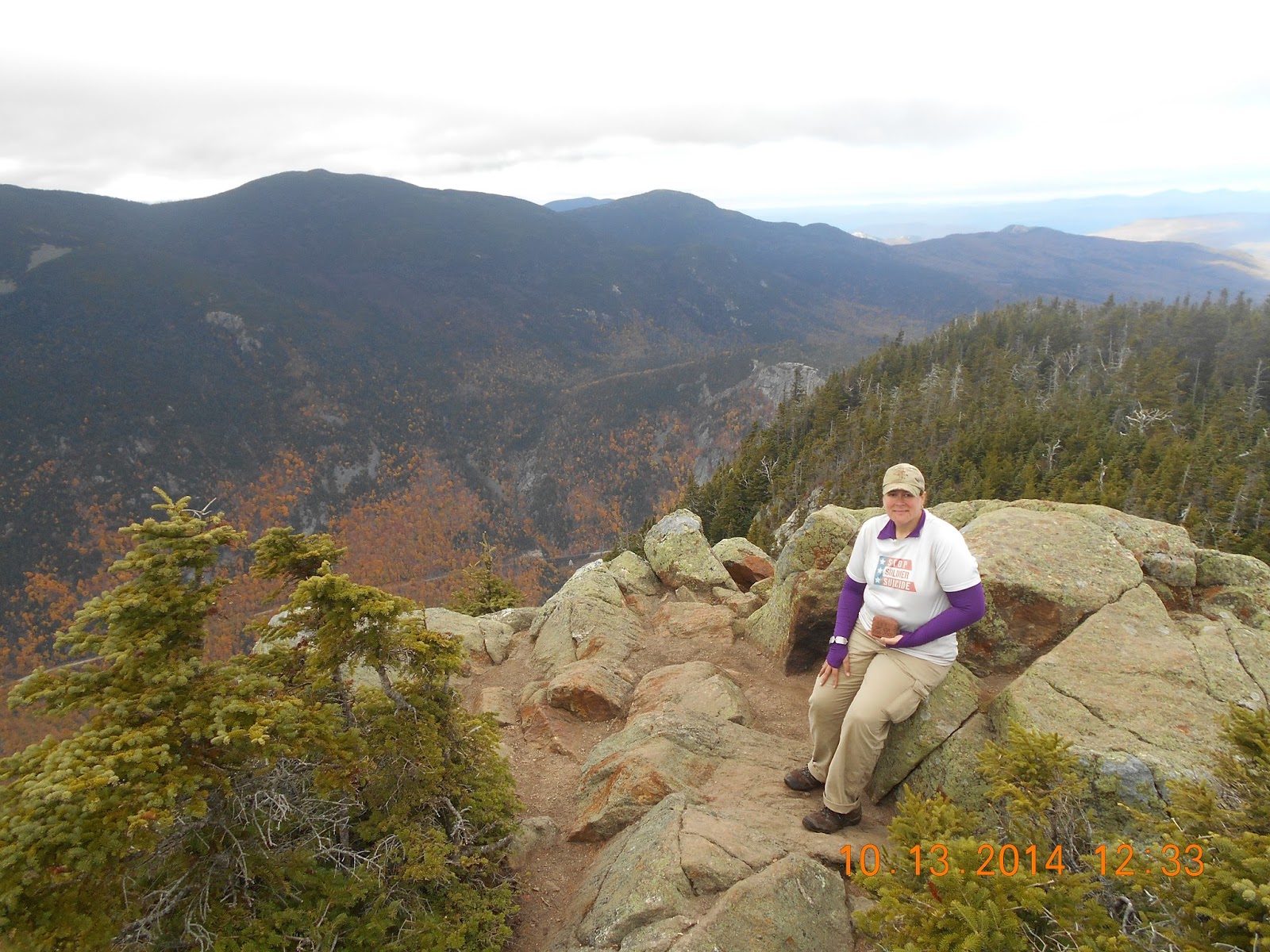
Monday 13 October, Wow, what a change one night makes. Today we woke up to an absolutely gorgeous day, no rime ice or cloud in site. Today we finished off the second half of the southern Presidentials, hiking from Mizpah Hut, summitting Mt. Jackson, summitting Mt. Webster, traversing Webster Cliffs and then descending down into Crawford Notch. It was a great day of hiking except for the last bit across and down Webster Cliffs into Crawford Notch. The hike down was very steep and Mom was not a happy camper. No one had mentioned that this section of the trail was so steep, treacherous or gnarly, but note to self...it is!! Go up it, not down it!!! We made it though and completed The Presidential Range, yay!! We went into Conway for the night, as Hendo needed a new pair of shoes.

Looking back at Mizpah Hut, little white speck off in the distance. Mt. Washington and Presidential Range in the background.

Mizpah Hut

Hendo's Mom at the summit of Mt. Jackson

Hendo on the summit of Mt. Jackson

Hendo's Mom with MSgt Love's Memorial Stone on the summit of Mt. Webster
Hendo with SPC Cassavant's Memorial Stone on the summit of Mt. Webster
6-10 October: Northern Presidentials
Because of Mother Nature, and her extreme moods, we are tackling The Whites in sections. The nortghern half of the Presidential Range is the roughest/hardest section of the The Whites, so we decided to take it on first.
My CVMA sister, Wingnut, gave us a ride to the top of Mt. Washington to begin our trek north on Monday 6 Oct. It was windy, but clear and beautiful on top os Mt. Washington. Christine. The mother of SPC Cassavant (whose memorial stone we are carrying), joined us for our send-off.


My CVMA sister, Wingnut, gave us a ride to the top of Mt. Washington to begin our trek north on Monday 6 Oct. It was windy, but clear and beautiful on top os Mt. Washington. Christine. The mother of SPC Cassavant (whose memorial stone we are carrying), joined us for our send-off.
Looking up at Mt. Washington, sunny and clear.
Hendo's Mom with MSgt Love's Memorial Stone and Hendo with SPC Cassavant's Memorial stone on top of Mt. Washington.

Christine, SPC Cassavant's Mother, and Hendo with SPC Cassavant's Memorial stone on Mt. Washington

Wingnut and Hendo with CVMA Chapter 17-1 Banner on Mt. Washington
So after a great lunch and send-off on top of Mt. Washington Mom and I were on our way. We made it down Mt. Washington, around Mt. Clay, around Mt. Jefferson and down to The Perch Shelter on Monday 6 October.
Tuesday 7 October and Wednesday 8 October, Mother Nature introduced us to her crazy Whites weather Tuesday and Wednesday. Severe thunderstorms rolled in along with 60-70 mph winds, so we had to hunker down at the shelter and wait it out.

This is why we waited 2 days.
Thursday 9 October, The crazy weather subsided and we were able to head back up to the ridgeline and finish the northern half of the Presidentials hiking from The Perch, around Mt. Adams, over Mt. Madison, 5367 ft and down to Osgood Tentsite. What a day of hiking it was!! Mt. Katahdin was still harder, but Mt. Madison was insane to say the least. Bad weather started moving in towards the end of the day and a 50-60 mph gust of wind blew Hendo down while coming down Mt. Madison. No injuries were sustained and that brief introduction to Mother Nature's White weather was more than enough.

A light coat of frost/ice covered the landscape.

Hendo hiking down towards Madison Hut. Mt. Madison looms in the background, we summitted Mt. Madison.

Hendo's Mom climbing up Mt. Madison with Mt. Washington white capped in the background.

Hendo's Mom with MSgt Love's Memorial Stone at the Summit of Mt. Madison, 5367 ft

Hendo with SPC Cassavant's Memorial Stone on the Summit of Mt. Madison, 5367 ft.
Friday 10 Oct, Today we hiked on down to Pinkham Notch, completing the northern half of The Presidential Range, The White Mountain, NH.
Food Bags Located and Secured!!!
So today we got shut off of Mt. Lafayette AGAIN do to weather, so we are in town checking voicemail and internet. Got a message and spoke to the gentlemen, Scott, who mistakenly took our food bags. Scott thought that the Boy Scouts camped across from our location left the food bags in the trees. Since Scott would be passing by the town the Boy Scouts were from on his way home, he took down the bags and delivered them to the Boy Scouts. Upon delivering our bags to the Boy Scouts he learned that they were in fact our bags. Scott tracked down our website and left me text and voicemails. I called and spoke with him today. He is going to reimburse us for the cost of our replacement food and bags that we had to buy and is mailing our bags to us on down the trail. So all is well, and he meant well. Good to learn that they weren't stolen, just a misunderstanding.
Sunday, October 26, 2014
Someone Stole Our Food Bags this Morning!!!!!
And Murphy strikes again. Someone stole our food bags full of food, 50 ft of paracord rope line and 2 carabeeners hanging in a tree 30 ft from our tent this morning. Our food bags were hanging in the tree at 0530 hrs this morning when I got ip to go pee, but was gone when we came out of our tent at 0900hrs. Total cost of gear and food is $250. The Whites are beating us up, glad we are almost done!!
Saturday, October 11, 2014
30 September-5 October: Conquering the Wildcats, The White Mountains, New Hampshire!!!!
Winter will soon be setting into The White Mountains in New Hampshire. Therefore, we decided to jump down to New Hampshire from Caratunk, ME and complete The Whites before we are closed out of them by winter weather. A CVMA sister, Wingnut, who lives in Maine, graciously offered to give us a ride from Caratunk, ME to Gorham, NH (The White Mountains). So Wingnut picked us up on Tues 30 Sept and drove us to New Hampshire. We started hiking on Thurs 2 Oct.
Thursday, 2 October, it was recommended we go north over the Wildcat Mountain section of The Whites, so today we started at Pinkham Notch and Headed north, climbing over Wildcats E, D, C B and A. As you will see below the climb up the Wildcats was very steep and it was definitely a better choice to go up than down them. Contrary to what most might think, going down such steep climbs is so much harder and dangerous, up is crazily the easier way to do it.


There are 8 Appalachian Mountain Club Huts located throughout The White Mountains. You can go online and make reservations, hike in, get a hot dinner, dry bunk and hot breakfast. As thru-hikers, the huts will take in a few thru-hikers for Work For Stay each evening. For Work For Stay, the huts will feed you dinner and breakfast leftovers and allow you to sleep on the floor of the dining room, in return for some help washing dishes or clean up the hut.


Thursday, 2 October, it was recommended we go north over the Wildcat Mountain section of The Whites, so today we started at Pinkham Notch and Headed north, climbing over Wildcats E, D, C B and A. As you will see below the climb up the Wildcats was very steep and it was definitely a better choice to go up than down them. Contrary to what most might think, going down such steep climbs is so much harder and dangerous, up is crazily the easier way to do it.
Hendo's Mom climbing up Wildcat E.
Mom asking where the "hiking" is in this section.
Boulders lodged in the crag to make "steps".
Hendo climbing up the wooden blocks secured to the side of Wildcat E's sheer face section.
A view of Mt. Washington from ontop Wildcat E
Hendo and Hendo's Mom ontop Wildcat E and above the clouds, undercast is cool.
Moose tracks along the trail of Wildcats Ridgeline
There are 8 Appalachian Mountain Club Huts located throughout The White Mountains. You can go online and make reservations, hike in, get a hot dinner, dry bunk and hot breakfast. As thru-hikers, the huts will take in a few thru-hikers for Work For Stay each evening. For Work For Stay, the huts will feed you dinner and breakfast leftovers and allow you to sleep on the floor of the dining room, in return for some help washing dishes or clean up the hut.
Off in the distance Carter Notch Hut, small green roofs in the valley, where we will spend the night tonight.
Closer picture of Carter Notch Hut
Friday 3 October, Today we hiked over Carter Dome and Mt Hight.
Hendo on top of Mt. Hight
Sat 4-Sun 5 Oct, Mother Nature intervened and brought in some sketchy weather so we had to zero.
19 Sept- 29 Sept: Monson to Caratunk, Maine
19 Sept- 29 Sept: Monson to Caratunk, Maine
So we finally got Mom well, got back on trail and headed south. But Murphy struck one more time and put a hole in my sleeping pad, therefore it would not stay inflated and insulate me from the cold ground. This is not good, especially when it is colder at night. We weren't too far from Monson, so we got back into town, ordered a replacement one to be picked up 3 days on down the trail, temporarily fixed the hole in my old one and headed on our way again.
Wednesday 24 September, Each year there are always some thru-hiker trail "celebrities". This year two of those such celebrities were Engineer and Color Bandit. Engineer is an aerospace engineer and amazing artist, Color Bandit is one of the nicest guys around who hiked with a set of crayons. Engineer would draw amazing pictures in the shelter log books and Color Bandit would follow behind and color in Engineer's pictures. We met Color Bandit back in Tennessee but Engineer was far too fast and ahead of us, for us to meet him while we were still headed north. Well, when we flip-flopped and began heading south, we started to pass a lot of people we had started hiking with down south. On Wed 24 Sept, we were lucky enough to cross paths with Engineer. Whoohoo!!!! Thanks so much to Engineer and his awesome pictures, which he says he is going to compile into a book. Getting to the next shelter to see his next great picture was often our daily motivation!!

Hendo, Engineer and Hendo's Mom
Wednesday 24 Sept, Hendo got a nother booboo. Fording the West Branch of the Piscataquis River, my foot slipped on a rock and another rock was nice enough to leave its mark on my shin. Guys dig scars, right?!?!?

Hendo's Latest Booboo
Thursday 25 September, Getting sick sucks, getting sick out in the woods on the trail sucks more. After fording the Piscataquis and cutting my leg, I started feeling sick later in the afternoon. I don't think it was related, just circumstance. Anyway, spent all day Thursday 25 Sept, sick with diarrhea, running to and from the tent and a slit trench latrine I dug for myself, catholes weren't cutting it. Thankfully it only lasted a day a Friday we were able to continue trudging south.

Beautiful fall colors in Maine.

Hendo, Lately and dog Early.
We were rewarded Friday night, 26 Sept, with a great camping spot along Bald Mountain Pond at the Moxie Bald Mountain Lean-to. It was absolutely gorgeous!! A mother moose and two calves joined us for dinner. They sloshed down into the pond approximately 200 meters away, and hung out for 1.5 hours eating water plants along the shore. We sat on the granite slab seen below and enjoyed our dinner as well.

Hendo reading the shelter log book at Moxie Bald Mountain Lean-to

A Mama moose with two calves following behind, enjoying their dinner with us.


A "dinosaur" footprint on our way up Moxie.

Hendo's Mom on top of Moxie Bald Mountain, gorgeous view.
Time got away from us today, ie. we visited too long with people along the trail, and ended up still on the trail after dark. We never purposely night hike, but a few times we have been caught still on the trail after dark. Mom is not a fan because she cannot see well, so Saturday night we got caught on the trail after dark and eventually came across a wide flat area, so we stopped and set up our tent. At the time we didn't realize we were, on the trail still. Oh well, there was plenty of room for people to hike on by if needed. So goes life on the trail.


Subscribe to:
Posts (Atom)